Some general improvements to functionality that were released during the week (Dec 11), will try to keep posting these as they come up.
Increasing functionality based on user feedback is important for customer retention and then can be used to drive sales, so important one to watch.
-------------------------------------------------------------------------------------------------------------------------------------------------------------------------------
We've been working on a number of customer requests and general improvements to existing functionality. Here are the highlights...
ScanView
- You can now display the location of the other scan stations while in the spherical image view. Use the new "show scan markers" button to toggle the display. If you hover over a scan marker in the image view, the corresponding scan station will also be highlighted on the overview map (if the overview map panel if currently visible), and vice-versa.
- When scan markers are displayed, you have the option to filter the markers based on their distance from your current scan station. Use the edit button to adjust the distance as required.
- The split screen view (with scan stations shown on the overview map) now has a resizable layout. Grab the resize handle between the left panel and the main image viewer to drag to a new size. Your preferred size will be remembered.
3D Viewer
- Coordinates are now displayed with units (e.g. ft) as appropriate for the spatial reference system of the point cloud.
- Point cloud visibility is now stored as part of bookmarks data.
- Coloured intensity now stretches to both minimum and maximum values (previously was 0 to max)
Datasets
- Vector datasets now have basic styling options to set point, line, and polygon colours and widths. The initial version used a text-based editor - a more comprehensive graphical editor will be released soon.
- A new Feature Query Tool has been added to the main toolbar. This allows attribute interrogation of vector layers. The attributes that are displayed will depend on what was present in the original SHP, DXF, or KML file.
Visit the Pointerra help site for more details on using these new features.
- Improved recognition of spatial reference information when uploading ECW files.
- 360 pano photo datasets can now have the camera direction property (forward/backward) edited after creation
General
- The well-known spatial reference name is now displayed as part of spatial reference information
- EPSG code is now displayed as part of the spatial reference information (if an EPSG code exists)
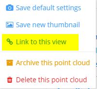
- There is now a "Link to this view" option available from the actions menu. This will generate a URL that links back to the current camera view. Note that, unlike a share token, the link requires the user to have permissions to view the point cloud.
---------------------------------------------------------------------------------------------------------------------------------------------------------------------------------------------
- Forums
- ASX - By Stock
- Functionality updates
Some general improvements to functionality that were released...
Featured News
Add 3DP (ASX) to my watchlist
 (20min delay) (20min delay)
|
|||||
|
Last
4.4¢ |
Change
-0.002(4.35%) |
Mkt cap ! $42.66M | |||
| Open | High | Low | Value | Volume |
| 4.6¢ | 4.6¢ | 4.3¢ | $7.46K | 169.4K |
Buyers (Bids)
| No. | Vol. | Price($) |
|---|---|---|
| 2 | 33526 | 4.3¢ |
Sellers (Offers)
| Price($) | Vol. | No. |
|---|---|---|
| 4.6¢ | 70000 | 1 |
View Market Depth
| No. | Vol. | Price($) |
|---|---|---|
| 2 | 173926 | 0.053 |
| 3 | 71062 | 0.051 |
| 3 | 100898 | 0.050 |
| 2 | 200000 | 0.049 |
| 2 | 165000 | 0.048 |
| Price($) | Vol. | No. |
|---|---|---|
| 0.054 | 37619 | 1 |
| 0.057 | 34225 | 1 |
| 0.058 | 110423 | 2 |
| 0.059 | 250000 | 1 |
| 0.060 | 75000 | 1 |
| Last trade - 15.52pm 19/11/2024 (20 minute delay) ? |
Featured News
| 3DP (ASX) Chart |


